Posted by Anne M on Monday, May 19, 2014
Have you ever thought your house was older than the date listed on your property report? Find it odd that many property reports list 1900 as the year built? Perhaps everyone in Iowa City had house-building fever at the beginning of the 20th century, but the more likely reason is that this date was the generic date used for anything built around 1900 when the files were moved to an electronic version. (There are other theories on these dates and if you have one, please let us know.) If you need a better estimate than “old,” there are a few resources you can turn to at the Iowa City Public Library and online.
Melody discussed one of them, city directories, in a recent blog post. You can look up by address and trace your house that way. They offer interesting information about who lived there as well as employment.
Following the Civil War, the Sanborn Company started drawing detailed maps of buildings in urban areas to indicate
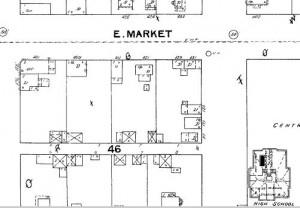 fire hazards. The bonus, unintended consequence is that we have a great resource in observing cities develop, as well as changes to a specific property. They are available for over 12,000 locations throughout the United States, including Iowa City. On microfilm, ICPL has Iowa City maps for the years 1883, 1888, 1892, 1899, 1906, 1912, 1920, 1926, and 1933. Iowa City is about halfway through each reel. The image to the right is from the 1892 map of the corner of Market and Gilbert (the current block of John's Grocery). The old high school is in the bottom right corner, where a parking garage for Mercy is currently located. (Our new microfilm reader allows you to crop and edit images, as well as print, email, or save your information.)
Johnson County GIS Property Information Viewer
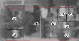
If your house was built between 1930 and the present, you can view aerial maps of your property on the Johnson County GIS Property Information Viewer website. Some images are clearer than others (the image below is from the 1960's and is clear enough), but it is interesting to see how your house, as well as the property around it has changed. It also allows you to layer attributes to the map, including elevations, flood hazards, and zoning.
Happy searching!
About the Author

Anne Mangano has worked for the Iowa City Public Library since 2008, serving as the Collection Services Coordinator since 2013. In this position, she oversees ICPL's collection, including the selection, cataloging, processing, repair, and removal of materials, including the library's digital collections. Anne holds a Bachelor of...
Emily St. John Mandel seems to brilliantly encapsulate all of modern fears in the sum of 255 pages. Or are they just human fears? This book, spanning centuries, from the 1910's to the 2300's, takes on post-traumatic stress disorder, pandemics, technological shifts, and the fragility of Earth and its nations. And like always, St. John Mandel leaves me with more questions than answers. -Anne M